![](/images/other/stat-length.png)
![Randonnée Marche Viacamp y Litera - Congost de Mt Rebei et passerelles - Photo](https://media.geolcdn.com/t/1900/400/ext.pjpeg?maxdim=2&url=https%3A%2F%2Fstatic1.geolcdn.com%2Fsiteimages%2Fupload%2Ffiles%2F1553511878bg_sport_marche.png)
Congost de Mt Rebei et passerelles
pacha56
Utilisateur
![Longueur](/images/other/stat-length.png)
Longueur
11,2 km
![Altitude max](https://static1.geolcdn.com/siteimages/upload/files/1508320355ic_sort_altitude_max_24dp.png)
Altitude max
820 m
![Dénivelé positif](https://static1.geolcdn.com/siteimages/upload/files/1508320355ic_sort_den_pos_24dp.png)
Dénivelé positif
752 m
![Km-Effort](/images/other/stat-length.png)
Km-Effort
21 km
![Altitude min](https://static1.geolcdn.com/siteimages/upload/files/1508320355ic_sort_altitude_min_24dp.png)
Altitude min
498 m
![Dénivelé négatif](https://static1.geolcdn.com/siteimages/upload/files/1508320355ic_sort_den_neg_24dp.png)
Dénivelé négatif
753 m
![Boucle](https://static1.geolcdn.com/siteimages/upload/files/16400158638029165_repeat_loop_refresh_sync_direction_icon.png)
Boucle
Oui
Date de création :
2022-06-28 09:02:32.88
Dernière modification :
2022-06-28 19:27:42.491
![Marche](https://static1.geolcdn.com/sitytour/trail-icons/101.png)
6h28
Difficulté : Difficile
![Scannez ce code QR pour ouvrir la randonnée dans l'application SityTrail](https://capi.geolives.com/qq0zvz2zws4bq2lad0pu/sitytour/trails/3298164/qr.png?size=200)
Application GPS de randonnée GRATUITE
À propos
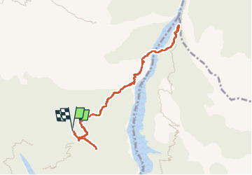
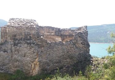
Randonnée Marche de 11,2 km à découvrir à Aragon, Huesca, Viacamp y Litera. Cette randonnée est proposée par pacha56.
Description
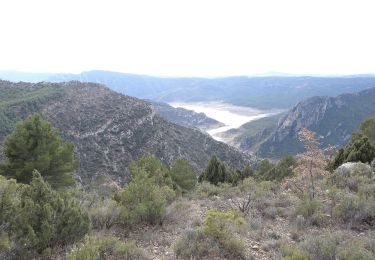
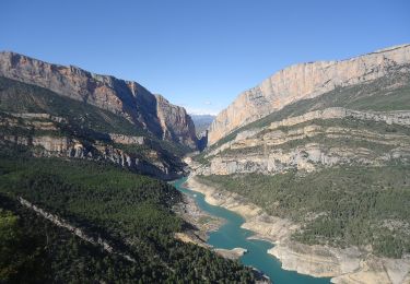
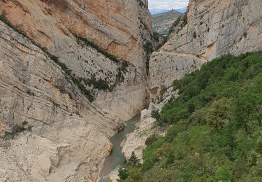
Superbe randonnée, en partant de l'auberge du Mt Falco , montée à l'ermitage Santa Quiteria, où la vue est magnifique. puis redescente et passage des 2 passerelles très aériennes. Si vous avez le vertige, c'est non..
Localisation
Pays :
Espagne
Région :
Aragon
Département/Province :
Huesca
Commune :
Viacamp y Litera
Localité :
Unknown
Départ:(Dec)
Départ:(UTM)
305843 ; 4658418 (31T) N.
Commentaires
Randonnées à proximité
![Randonnée A pied Àger - La Pertusa-Congost de Mont-rebei - Photo](https://media.geolcdn.com/t/375/260/ext.jpg?maxdim=2&url=https%3A%2F%2Fmedia.geolcdn.com%2Ff%2Fdf959b45-5184-45b2-a14f-12ec90c41f0c.jpeg)
![A pied A pied](https://static1.geolcdn.com/sitytour/trail-icons/100.png)
La Pertusa-Congost de Mont-rebei
A pied
Facile
Àger,
Catalogne,
Lérida,
Espagne
![](/images/other/stat-length.png)
9,2 km | 15,2 km-effort
3h 27min
![](https://static1.geolcdn.com/siteimages/upload/files/16400158638029165_repeat_loop_refresh_sync_direction_icon.png)
Non
![Randonnée A pied Sant Esteve de la Sarga - Congost de Mont-rebei - Photo](https://media.geolcdn.com/t/375/260/ext.jpg?maxdim=2&url=https%3A%2F%2Fmedia.geolcdn.com%2Ff%2Fe6be82de-dd56-4d87-809b-865b5e0cb050.jpeg)
![A pied A pied](https://static1.geolcdn.com/sitytour/trail-icons/100.png)
Congost de Mont-rebei
A pied
Facile
Sant Esteve de la Sarga,
Catalogne,
Lérida,
Espagne
![](/images/other/stat-length.png)
7 km | 10,3 km-effort
2h 21min
![](https://static1.geolcdn.com/siteimages/upload/files/16400158638029165_repeat_loop_refresh_sync_direction_icon.png)
Oui
![Randonnée Marche Viacamp y Litera - Congost de Mont Rebai - Photo](https://media.geolcdn.com/t/375/260/ext.jpg?maxdim=2&url=https%3A%2F%2Fmedia.geolcdn.com%2Ff%2Fb7c3a555-deb6-4cfd-8226-bc7e6c6f79d4.jpg)
![Marche Marche](https://static1.geolcdn.com/sitytour/trail-icons/101.png)
Congost de Mont Rebai
Marche
Difficile
Viacamp y Litera,
Aragon,
Huesca,
Espagne
![](/images/other/stat-length.png)
11,7 km | 24 km-effort
4h 51min
![](https://static1.geolcdn.com/siteimages/upload/files/16400158638029165_repeat_loop_refresh_sync_direction_icon.png)
Oui
![Randonnée Marche Viacamp y Litera - muraille de finestret - Photo](https://media.geolcdn.com/t/375/260/ext.jpg?maxdim=2&url=https%3A%2F%2Fservices.sitytrail.com%2FGeolivesWS%2FDownloadMedia.ashx%3FTrailID%3D960943%26Media%3Dfix__20180506135905.jpg)
![Marche Marche](https://static1.geolcdn.com/sitytour/trail-icons/101.png)
muraille de finestret
Marche
Moyen
Viacamp y Litera,
Aragon,
Huesca,
Espagne
![](/images/other/stat-length.png)
9,8 km | 14,9 km-effort
3h 40min
![](https://static1.geolcdn.com/siteimages/upload/files/16400158638029165_repeat_loop_refresh_sync_direction_icon.png)
Oui
![Randonnée Marche Viacamp y Litera - Boucle Monfalco - Photo](https://media.geolcdn.com/t/375/260/ext.jpg?maxdim=2&url=https%3A%2F%2Fstatic1.geolcdn.com%2Fsiteimages%2Fupload%2Ffiles%2F1553511878bg_sport_marche.png)
![Marche Marche](https://static1.geolcdn.com/sitytour/trail-icons/101.png)
Boucle Monfalco
Marche
Très facile
Viacamp y Litera,
Aragon,
Huesca,
Espagne
![](/images/other/stat-length.png)
5,8 km | 9,5 km-effort
1h 49min
![](https://static1.geolcdn.com/siteimages/upload/files/16400158638029165_repeat_loop_refresh_sync_direction_icon.png)
Oui
![Randonnée Marche Sant Esteve de la Sarga - Le Congost de Mont Rebeil - Photo](https://media.geolcdn.com/t/375/260/ext.jpg?maxdim=2&url=https%3A%2F%2Fstatic1.geolcdn.com%2Fsiteimages%2Fupload%2Ffiles%2F1553511878bg_sport_marche.png)
![Marche Marche](https://static1.geolcdn.com/sitytour/trail-icons/101.png)
Le Congost de Mont Rebeil
Marche
Moyen
Sant Esteve de la Sarga,
Catalogne,
Lérida,
Espagne
![](/images/other/stat-length.png)
14,2 km | 27 km-effort
4h 45min
![](https://static1.geolcdn.com/siteimages/upload/files/16400158638029165_repeat_loop_refresh_sync_direction_icon.png)
Oui
![Randonnée Marche Sant Esteve de la Sarga - Congost de Mont Rebei - Photo](https://media.geolcdn.com/t/375/260/ext.jpg?maxdim=2&url=https%3A%2F%2Fstatic1.geolcdn.com%2Fsiteimages%2Fupload%2Ffiles%2F1553511878bg_sport_marche.png)
![Marche Marche](https://static1.geolcdn.com/sitytour/trail-icons/101.png)
Congost de Mont Rebei
Marche
Facile
Sant Esteve de la Sarga,
Catalogne,
Lérida,
Espagne
![](/images/other/stat-length.png)
11 km | 17,6 km-effort
Inconnu
![](https://static1.geolcdn.com/siteimages/upload/files/16400158638029165_repeat_loop_refresh_sync_direction_icon.png)
Oui
![Randonnée Marche Viacamp y Litera - Montfalco mont Rebei - Photo](https://media.geolcdn.com/t/375/260/ext.jpg?maxdim=2&url=https%3A%2F%2Fstatic1.geolcdn.com%2Fsiteimages%2Fupload%2Ffiles%2F1553511878bg_sport_marche.png)
![Marche Marche](https://static1.geolcdn.com/sitytour/trail-icons/101.png)
Montfalco mont Rebei
Marche
Difficile
Viacamp y Litera,
Aragon,
Huesca,
Espagne
![](/images/other/stat-length.png)
8,2 km | 16 km-effort
3h 38min
![](https://static1.geolcdn.com/siteimages/upload/files/16400158638029165_repeat_loop_refresh_sync_direction_icon.png)
Oui
![Randonnée Marche Viacamp y Litera - Boucle Monfalco FET Monfalco - Photo](https://media.geolcdn.com/t/375/260/ext.jpg?maxdim=2&url=https%3A%2F%2Fstatic1.geolcdn.com%2Fsiteimages%2Fupload%2Ffiles%2F1553511878bg_sport_marche.png)
![Marche Marche](https://static1.geolcdn.com/sitytour/trail-icons/101.png)
Boucle Monfalco FET Monfalco
Marche
Moyen
Viacamp y Litera,
Aragon,
Huesca,
Espagne
![](/images/other/stat-length.png)
12,2 km | 20 km-effort
4h 31min
![](https://static1.geolcdn.com/siteimages/upload/files/16400158638029165_repeat_loop_refresh_sync_direction_icon.png)
Oui